Tornadoes Are Now Possible Today Across Deep East Texas
Over the past few days, meteorologists have been alerting folks that live across parts of central and east Texas to be ready for the possibility of flooding due to heavy rainfall through Wednesday. In fact, a Flood Watch is in effect through 7 a.m. on Thursday.
But Wait...There's More
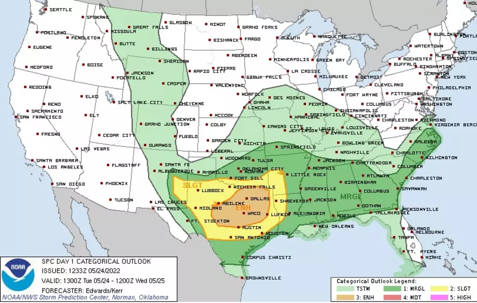
Now, the Storm Prediction Center in Norman, Oklahoma is advising residents from the Texas Hill Country to Austin/Dallas to parts of East Texas to be on the lookout for a severe weather breakout on Tuesday afternoon and evening. Damaging straight-line winds gusting to over 60 mph, large hail, and several tornadoes could happen across the area. That's in addition to the heavy downpours that could bring flooding to the Pineywoods.
Check Out the Probability Maps for Severe Weather, Hail, and Tornadoes


According to these maps, not all of Deep East Texas is included in the shaded areas that designate the highest probability of severe weather components, but, it looks like both Lufkin and Nacogdoches are included in those high probability areas. Lucky us.
The Timing of the Storms
Monday evening, severe storms erupted across South Texas and eventually went out into the Gulf of Mexico. Now, that same system has turned northeastward and should bring a severe weather threat along the Highway 59 corridor later this afternoon and evening. Once that system passes, another one should enter our area overnight. The main threat from the overnight system will be heavy rainfall and the possibility of some hail and straight-line winds.
As always, listen to KICKS 105 for updates and download our free KICKS 105 App to have weather alerts sent straight to your smartphone.

DPS Helicopter Gives Us Aerial View Of Storm Damage In Cushing, Texas
More From Newstalk 860