Lufkin, Nacogdoches Should Prepare for Dangerous Weather Outbreak
Monday afternoon through early Tuesday morning, a severe weather outbreak across Deep East Texas looks to be a certainty. Stormy weather during the Spring months in the Pineywoods is a pretty common occurrence, but this round of anticipated bad weather has many meteorologists on edge.
Why The Big Concern?
For the past several days, the Storm Prediction Center in Oklahoma has been blowing the horn about a nasty batch of severe weather that is expected to unleash its wrath over parts of Texas, Louisiana, Mississippi, and Alabama on Monday and Tuesday. Today's noon update (3/20) from the SPC shows a large area of central to east Texas to be the bubble for the highest probability of severe storms come Monday afternoon through early Tuesday morning. That bubble includes Austin, Houston, Bryan/College Station, along with Lufkin and Nacogdoches. It looks like scattered storms could start Monday afternoon, but the largest outbreak of bad weather should hit us Monday night through early Tuesday morning.
What Can We Expect in Deep East Texas?
In a word...everything.
Pre-storm winds: Before the storms even get here, southerly winds ahead of the system could gust to over tropical storm strength (39 mph+) across Deep East Texas. That's more than strong enough to bring down a few limbs and possibly lead to some scattered power outages.
Very large hail: This could be a widespread hail event for central and east Texas. Don't be surprised to see reports of golf-ball-sized hail or larger across our area. The best chance of very large hail will be in central Texas through parts of the Texas Hill Country.
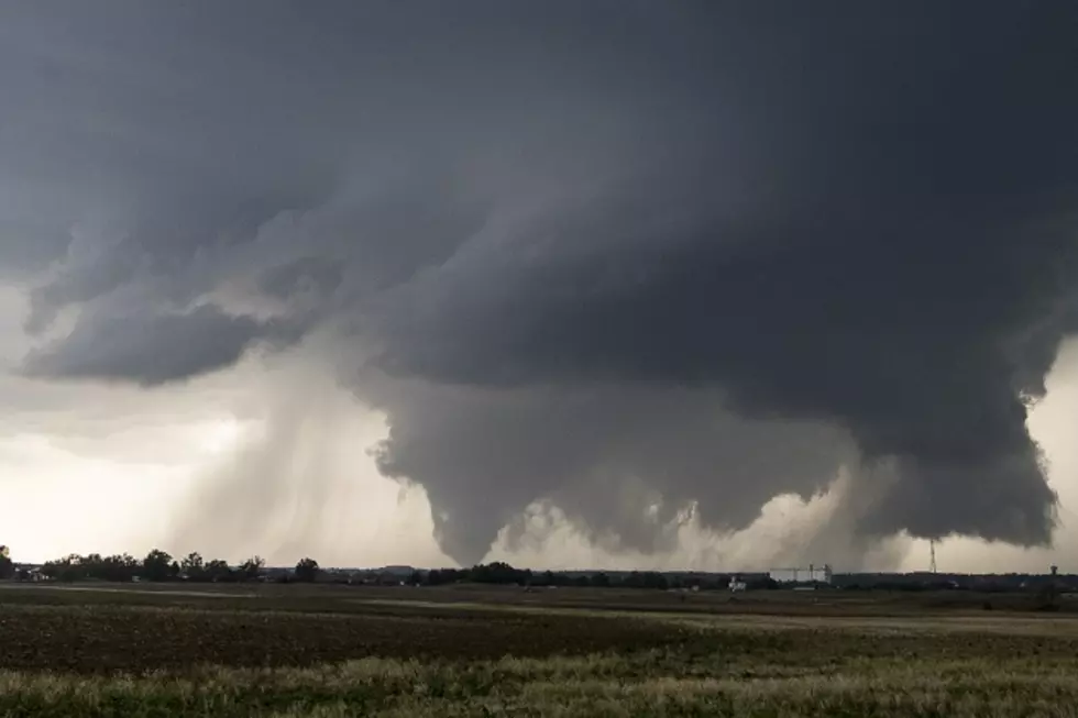
Tornadoes: Unfortunately, it's looking like several twisters will be produced by this vigorous storm system. Once again, most of central Texas and east Texas are in play. Meteorologists are also warning of the possibility of 'strong' tornadoes. That would mean that some of the tornadoes could produce winds well in excess of 111 mph.
Damaging straight-line winds: By Monday night, a well-developed line of thunderstorms should pass through the Pineywoods. Some of the storms within that large squall line could produce straight-line wind gusts in excess of 60 mph.
Flooding: The storm system is expected to slow its forward movement by late Monday night. This could allow for heavy downpours to 'train' over the same areas. The National Weather Service in Shreveport has earmarked an area that includes Lufkin and Nacogdoches that could see anywhere from 2 to 6 inches of rain leading to flash flooding.
Get Prepared
Given the high confidence in this severe weather outbreak, now is the time to think ahead and prepare for what may come to our region.
- If you have a generator, make sure it's filled with fuel and that you have extra fuel on hand. You may want to start it up if it has been a while since it last ran.
- Given the wind and hail forecast, make sure your vehicles are in the garage or under some sort of cover. Loose lawn-type furniture, trampolines, and trash cans should be stored or secured.
- In the event of a tornado, know exactly where the safest room in the house is located. Usually, that is an interior room with no windows and no exterior walls. Bring cushions to cover your body and wear a helmet if you have one. A mobile home provides little or no protection. If possible, make plans for Monday to stay in a safer structure.
- Keep your pets protected. If you can keep them inside the house or closed up in the garage, do so. If you have a pet that is spooked easily by thunder, make sure that he/she is not outside while storms are approaching as he/she may run away in panic.
- Most importantly, have a conversation with God and ask him to keep us safe.
It is my hope that the forecast's bark is worse than its bite. But, it is better to be prepared for what may not happen as opposed to not being prepared for what does happen. As always, listen to KICKS 105 for weather updates, and please download our free KICKS 105 App to have breaking weather updates sent to your smartphone.

LOOK: The most expensive weather and climate disasters in recent decades
More From Newstalk 860