Lufkin, Nacogdoches in the Bull’s Eye for 2 Severe Weather Events
It didn't take long for the humidity and above-normal temperatures to filter back into the Pineywoods. Wasn't it just a couple of days ago that we were experiencing wind chills below zero?
Anyone who has lived in East Texas for a while knows that when the warmer temps come in during the winter, we will probably get a round of strong storms when the next cold front approaches.
In this case, we are going to get two rounds of severe weather before the next cold blast comes to town.
Thursday's Severe Outlook and Timing
Thunderstorms are expected to increase across eastern Texas and western Louisiana throughout the afternoon and evening. The Storm Prediction Center is showing a high probability of storms between 5 pm and 9 pm across a swath of Deep East Texas...
...and that threat will continue through the overnight hours as well.
Some of those thunderstorms that do occur could reach severe limits. The biggest threats from these storms will be strong straight-line winds and a brief tornado or two can not be ruled out.
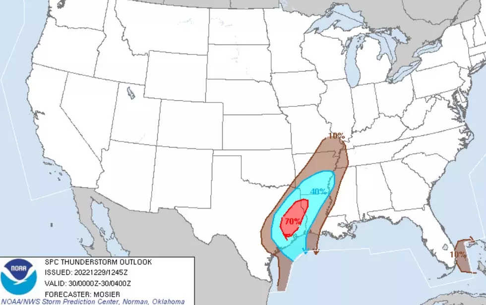
The map below shows that Lufkin, Nacogdoches and surrounding counties are in the shaded area marked for the highest probability of severe storms for Thursday and early Friday.
Another hazard from these thunderstorms will be heavy rainfall. The National Weather Service in Shreveport believes the heaviest downpours in East Texas will occur between 6 pm Thursday and 3 am Friday.
Combine those totals with the rain expected on Monday, and we could see upwards of 4-5 inches across the Pineywoods.
Cooler temperatures are expected to filter back into our region by late Monday, however, a stronger storm system will give East Texas a significant potential for a severe weather outbreak throughout the day on Monday.
The map above may not look too worrisome, but believe me, it's not good news when the Storm Prediction Center is confident enough to put up this kind of percentage 5 days out. Chances are very good that over the course of the next several days, the probability of a severe storm outbreak on Monday will greatly increase.
As always, listen to KICKS 105 for updates, and be sure to download our KICKS 105 App to have weather alerts sent to your smartphone.

Damage from Hurricane Ike
More From Newstalk 860